
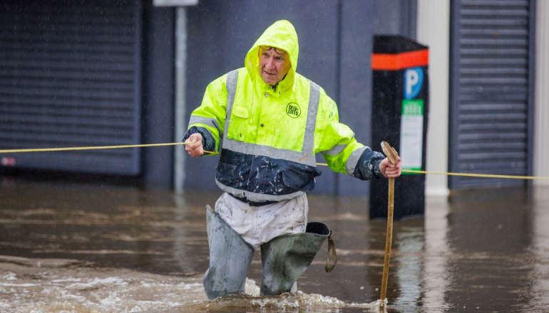
A major incident has been declared in Hampshire and on the Isle of Wight amid warnings that Storm Ciaran could pose a "risk to life" when it sweeps into England tonight.
Authorities said strong winds of up to 80mph were expected in coastal areas, potentially damaging buildings and causing trees to fall.
The storm is expected to arrive at around 6pm in Southampton, with the "major incident" status coming into force for the region from midnight.
The city's Itchen Bridge will also be closed from 7pm on Wednesday due to the expected high winds, officials said.
It comes after ferry services were cancelled and a red weather warning was issued for the Channel Islands.
Forecasters said gusts of 98mph could hit the islands on Wednesday evening, with wind speeds of up to 110mph in the middle of the English Channel, according to shipping forecasts.
High tides could also force the closure of coastal roads, and residents have been urged to "avoid outdoor activities".
In England, gusts could hit up to 95mph in some exposed areas.
Condor Ferries has already cancelled its freight and passenger routes between the Channel Islands and the UK on Wednesday and Thursday, while DFDS has axed services between Newhaven in East Sussex and Dieppe in France.
DFDS also has delays on its Dover-Calais routes due to high winds, while Brittany Ferries has warned of possible disruption to its cross-Channel routes.
It comes after the Met Office issued amber weather warnings for the South West and south coast of England for Thursday as Storm Ciaran approaches.
The agency said the wind and rain warnings would be in place from Wednesday night, with the storm due to cross southern Britain on Thursday.
Ahead of its arrival, parts of Northern Ireland have already been flooded by heavy rain and people have been warned not to travel.

Met Office yellow weather warnings for rain in the region were in place earlier today.
It warned of rainfall of between 25mm and 60mm in places, with up to 100mm on higher ground.
Amber weather warnings are in place for Cornwall and Devon between 3am and 11am on Thursday, and between 6am and 5pm the same day along the coast from Hampshire to Kent, as well as parts of East Anglia.
Forecasters said strong gusts - of 70mph to 80mph, perhaps exceeding 85 mph - could disrupt travel and cause damage to buildings, while flying debris could pose "a danger to life".
Separate yellow warnings for wind and rain are in place spanning Wales, southern and parts of eastern England until midnight on Thursday, with one warning remaining in place until 6am on Friday covering parts of northeast England and northeast Scotland.
#StormCiarán will bring very strong and damaging winds to the south of the UK on Wednesday evening and throughout Thursday
— Met Office (@metoffice) October 31, 2023
For more information on the warnings, visit https://t.co/QwDLMfRBfs
⚠️ Stay #WeatherAware pic.twitter.com/WYhlv5Xbfi
As of 1pm on Wednesday, 23 flood warnings have been issued, as well as 109 flood alerts across England.
Ben Lukey, flood duty manager at the Environment Agency, said parts of the south coast could see "significant flooding" on Thursday.
"Rain from the storm could also see significant surface water and river flooding across parts of the west, south and north east of England from later today until Friday, with minor impacts possible more widely on Saturday due to further showers," he said.
"We urge people to stay safe on the coast and to remember to take extreme care on coastal paths and promenades."
HM Coastguard has issued a warning for people to "stay away from the water's edge" and to avoid the areas most likely to be impacted by Storm Ciaran.

 Apply Now For Grant Funding To Help Strengthen Family Support On Isle Of Wight
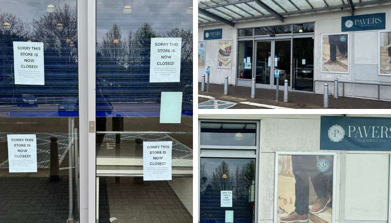 Pavers Shoes The Latest Newport Business To Close Its Doors
 Isle Of Wight Libraries Celebrate World Book Night
 Traffic Advice Issued For Walk The Wight
 Hovertravel's Hoverbus Showcases All-New Look
 Bear Grylls Pays Homage To Young Islander Ginny Following Ultimate Scouting Award
 Southern Vectis To Open May Community Fund For Worthy Causes Across Isle Of Wight
 Terrorism Plot Teen From Isle Of Wight Further Sentenced
 Ryde's Waterside Pool Secures £254,000 Of Government Refurbishment Funding
 Flood Warnings Eased But More 'Unsettled' Weather On The Way
 Sculpture To Commemorate People Affected By Dementia
 Police Appeal Launched Following East Cowes Waitrose Alcohol Theft
 Unmanned Dinghy Towed To Safety By Cowes Lifeboat
 Red Squirrel Property Shop Ventures Into Dubai Property Market
 Isle Of Wight MP Bob Seely Announces Blueprint To Fund A3055 Improvements
 New 2024/5 Annual Waste And Recycling Guide Out Soon
 Platform One Announces Winner Of 2024 Wight Noize Competition
 Royal Duke To Visit As Newport Minster Reopens
 Isle Of Wight Council To Support 'No Mow May' 2024
 English Coastal Path Complication Amid Osborne House Queen Victoria Collection Fears